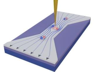
Toggle light / dark theme

Inspired by the tetromino shapes in the classic video game Tetris, researchers in the US have designed a simple radiation detector that can monitor radioactive sources both safely and efficiently. Created by Mingda Li and colleagues at the Massachusetts Institute of Technology, the device employs a machine learning algorithm to process data, allowing it to build up accurate maps of sources using just four detector pixels.

\r \r.

Wherever there is a risk of radioactive materials leaking into the environment, it is critical for site managers to map out radiation sources as accurately as possible.

Driving at night might be a scary challenge for a new driver, but with hours of practice it soon becomes second nature. For self-driving cars, however, practice may not be enough because the lidar sensors that often act as these vehicles’ “eyes” have difficulty detecting dark-colored objects. Research published in ACS Applied Materials & Interfaces describes a highly reflective black paint that could help these cars see dark objects and make autonomous driving safer.

Lidar, short for light detection and ranging, is a system used in a variety of applications, including geologic mapping and self-driving vehicles. The system works like echolocation, but instead of emitting sound waves, lidar emits tiny pulses of near-infrared light. The light pulses bounce off objects and back to the sensor, allowing the system to map the 3D environment it’s in. But lidar falls short when objects absorb more of that near-infrared light than they reflect, which can occur on black-painted surfaces. Lidar can’t detect these dark objects on its own, so one common solution is to have the system rely on other sensors or software to fill in the information gaps. However, this solution could still lead to accidents in some situations. Rather than reinventing the lidar sensors, though, Chang-Min Yoon and colleagues wanted to make dark objects easier to detect with existing technology by developing a specially formulated, highly reflective black paint.

A novel mathematical technique from the University of Surrey now simplifies space mission planning by mapping efficient routes, akin to a subway map, potentially revolutionizing travel to the Moon and beyond.

Just as sat-nav did away with the need to argue over the best route home, scientists from the University of Surrey have developed a new method to find the optimal routes for future space missions without the need to waste fuel.

The new method uses mathematics to reveal all possible routes from one orbit to another without guesswork or using enormous computer power.

Can an exoplanet’s weather be mapped similar to weather on Earth and even some of the gas giants in our solar system? This is what a recent study published in Nature Astronomy hopes to address as a team of international researchers used NASA’s James Webb Space Telescope to investigated weather patterns on WASP-43 b, which is a “hot Jupiter” gas giant exoplanet located approximately 280 light-years from Earth. This study holds the potential to help astronomers develop new methods and techniques in conducting atmospheric science on planetary bodies light years from Earth.

Discovered in 2011 by the La Silla Observatory in Chile using the transit method, WASP-43 b has a radius just slightly larger than Jupiter and whose mass is slightly more than double an orbital period of 0.8 days. Because of this extremely close distance, WASP-43 b is tidally locked to its parent star, meaning one side always faces it while the opposite side always faces away from it. In 2014, NASA’s Hubble Space Telescope conducted its own weather mapping of WASP-43 b, discovering its atmosphere reflects only small amounts of sunlight, which is in stark contrast to the Earth, along with discovering the presence of water vapor. Additionally, WASP-43 b was also observed by the now-retired NASA Spitzer Space Telescope.

“With Hubble, we could clearly see that there is water vapor on the dayside. Both Hubble and Spitzer suggested there might be clouds on the nightside,” said Dr. Taylor Bell, who is a researcher from the Bay Area Environmental Research Institute and lead author of the study. “But we needed more precise measurements from Webb to really begin mapping the temperature, cloud cover, winds, and more detailed atmospheric composition all the way around the planet.”

Researchers at EPFL have created the first detailed model explaining the quantum-mechanical effects that cause photoluminescence in thin gold films, a breakthrough that could advance the development of solar fuels and batteries.

Luminescence, the process where substances emit photons when exposed to light, has long been observed in semiconductor materials like silicon. This phenomenon involves electrons at the nanoscale absorbing light and subsequently re-emitting it. Such behavior provides researchers with valuable insights into the properties of semiconductors, making them useful tools for probing electronic processes, such as those in solar cells.

In 1969, scientists discovered that all metals luminesce to some degree, but the intervening years failed to yield a clear understanding of how this occurs. Renewed interest in this light emission, driven by nanoscale temperature mapping and photochemistry applications, has reignited the debate surrounding its origins. But the answer was still unclear – until now.

China released the world’s first set of high-precision geological maps of the moon drawn by China’s scientific research team on Sunday, mainly based on scientific exploration data from the Chang’e Project.

The highest precision geological atlas of the whole moon, with a scale of 1:2.5 million, can visualize the craters on the lunar surface, rocks and minerals found on the satellite of the Earth, and what kind of geological activity the moon has experienced.

As the internationally used geological maps of the moon obtained by the Apollo program of the US cannot reflect the latest research results of mankind in recent decades, they are no longer able to meet the needs of future scientific research and lunar exploration, according to the Chinese Academy of Sciences (CAS).

Land subsidence is overlooked as a hazard in cities, according to scientists from the University of East Anglia (UEA) and Virginia Tech. Writing in the journal Science, Prof Robert Nicholls of the Tyndall Center for Climate Change Research at UEA and Prof Manoochehr Shirzaei of Virginia Tech and United Nations University for Water, Environment and Health, Ontario, highlight the importance of a new research paper analyzing satellite data that accurately and consistently maps land movement across China.

Fraunhofer researchers developed an easy-to-operate, unmanned watercraft that autonomously surveys bodies of water both above and below the surface and produces corresponding 3D maps.


The unmanned watercraft uses its GPS, acceleration and angular rate sensors, and a Doppler velocity log (DVL) sensor to incrementally feel its way along the bottom of the body of water. In combination with mapping software, laser scanners, and cameras enable the device to reconstruct high-precision 3D models of the surroundings above water. A multi-beam sonar integrated into the sensor system is used for underwater mapping and creating a complete 3D model of the bed.

“Our navigation system is semi-automatic in that the user only needs to specify the area to be mapped. The surveying process itself is fully automatic, and data evaluation is carried out with just a few clicks of the mouse. We developed the software modules required for the mapping and autonomous piloting,” explains Dr. Janko Petereit, a scientist at Fraunhofer IOSB.

During the journey, it autonomously avoids obstacles detected by the laser scanner and sonar and generates a 3D model in real time for navigation purposes, including dynamic objects such as moving vessels.